Update Geo Reference Operator
This operator updates the Geo reference of the
source product. The geocoding generated from the latitude and
logitude tie point grids of the source product is generally not
accurate. This is because topography was not taking into
consideration when latitude and longitude tie point grids were
generated. This operator generates a new geocoding for a given
source product using DEM, orbit state vectors of the source image,
and mathematical modeling of SAR imaging geometry.
Interpolation Methods Supported
The operator supports the following interpolation
methods:
- Nearest-Neighbour interpolation
- Bilinear interpolation
- Cubic Convolution interpolation
- Bicubic interpolation
- Bisinc interpolation
DEM Supported
Right now only the DEMs with geographic coordinates (Pא, Pא, Ph) referred to global geodetic ellipsoid
reference WGS84 in meters are properly supported.
By default the following DEMs are available:
- ACE
- GETASSE30
- SRTM 3Sec GeoTiff
- ASTER GDEM
Since the height information in ACE and SRTM is referred to
geoid EGM96, not WGS84 ellipsoid, correction has been
applied to obtain height relative to the WGS84 ellipsoid.
User can also use external DEM file which, as specified above,
must be WGS84 (Pא
, Pא, Ph) DEM in meters.
Parameters Used
The following parameters are used by the
operator:
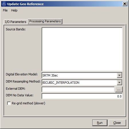
- Source Band: All bands (real or virtual) of the source product.
User can select one or more bands for target product. If no bands
are selected, then by default all bands are selected. The selected
bands together with lat_band and lon_band are output.
- Digital Elevation Model: DEM types. Choose from the
automatically tiled DEMs or specify using a single external DEM
file by selecting "External DEM".
- DEM Resampling Method: Interpolation method for obtaining
elevation values from the original DEM file.
- External DEM: User specified external DEM file. Currently only
WGS84-latlong DEM in meters is accepted as geographic
system.
- DEM No Data Value: Place holder for no data cell in DEM.
- Re-grid method: Checkbox indicating selection of one of the two
methods for defining lat/lon grid. By default, this checkbox is
unselected and source geocoding is used as the starting point in
computing the new geocoding. If this checkbox is selected, then a
lat/lon grid that covers the imaged area is used in computing the
new geocoding.