Supervised Wishart Classification Operator
Terrain classification is one of the most important
applications of polarimetric synthetic aperture radar. The
Supervised Wishart Classification technique classifies the image
into a number of clusters using Wishart distance measure and user
provided training data. Different from the Unsupervised Wishart
Classification, in the Supervised Wishart Classification the cover
types to be classified are selected by the user. In another word,
the clusters (for example, forest, water and urban) and their
locations are known in advance. This information is provided to the
classifier through user selected training data set. The training
set is selected for each class based on the ground truth map or
scattering contrast differences in PolSAR images. User locates
these areas on the image and guide the classifier with the help of
these training sites to learn the relationship between the data and
the classes. Finally, the image pixels are classified into one of
the clusters based on their Wishart distances to the center of the
cluster.
Therefore, this operator consists of two major processing steps:
- Supervised Training
- Wishart Classification
Supervised Training
To perform the supervised training,
the following steps should be followed:
- Display an intensity image on screen using RSTB (see Figure 1.
a subset of RadarSAT-2 data for San Francisco for example);
- Select areas as training data sets using the "Create a new
geometry container" and other drawing tools on the right hand side
of the tool box (in Figure 1, 8 areas for 5 classes have been
selected);
- Select "Supervised Classification Training" from the
"Polarimetric" menu, then highlight the training geometries and
click on "OK" to start the training. The center for the coherency
matrices of the pixels in each user identified class is computed
and save in a text file in user specified directory.
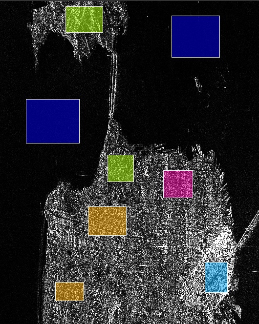
Figure 1. Training data set: 8
areas for 5 classes
Note that this processing step may take some time depending on the
number of classes, the number of areas and the size of the selected
areas.
Supervised Wishart Classification
In this processing step, all image pixels are
classified to one of the clusters based on their Wishart distances
to cluster centres.
The cluster centre
Vm
for the
m
th cluster is the average of the coherency matrices
of all pixels in the cluster. Mathematically it is given by
The Wishart distance measure from coherency matrix
T
to cluster centre
Vm
is defined
as the following:
where ln() is the natural logarithm function, |.| and
Tr(.) indicate the determinant and the trace of the matrix
respectively.
Input and Output
- The input to this operator can be qual-pol data or the
coherency / covariance matrix generated by Polarimetric Matrix
Generation operator.
- The output of this operator is supervised_wishart_class band
with pixel values being integers indicating the cluster indices.
User can give different colour to different cluster by using the
RSTB "Colour Manipulation" tool. (see Figure 2 for the
classification result of the example given in Figure 1).
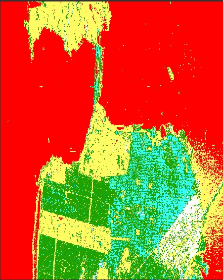
Figure 2. Classification
result
Parameters Used
For Supervised training, the following processing
parameter are needed (see Figure 3):
- Product: the source product
- Training Geometries: user identified classes
- File name: name for the text file in which cluster centers are
saved
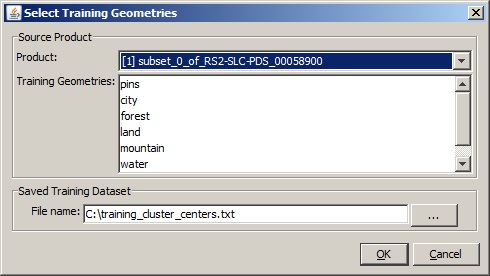
Figure 3. Dialog box
for Supervised training
For Supervised Wishart classification, the following parameters are
used (see Figure 4):
- Training Data Set: the text file in which the computed cluster
centers are saved
- Window Size: dimension of sliding window for computing mean
covariance or coherency matrix
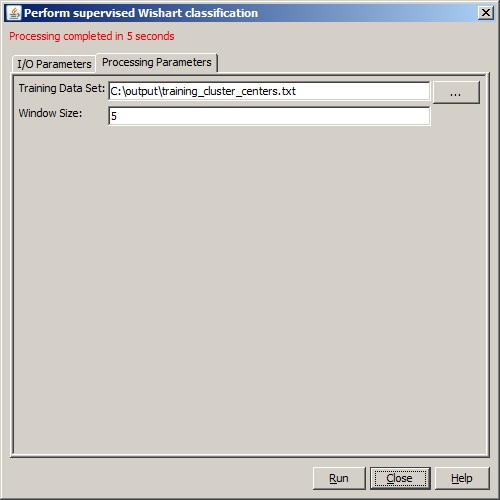
Figure 4. Dialog box for Supervised
Wishart classification
Reference:
[1] Jong-Sen Lee and Eric Pottier, Polarimetric Radar Imaging:
From Basics to Applications, CRC Press, 2009